


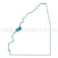
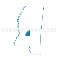
Flowood Voting District, Rankin County, Mississippi
About
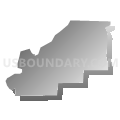
Outline

Summary
| Unique Area Identifier | 606577 |
| Name | Flowood Voting District |
| County | Rankin County |
| State | Mississippi |
| Area (square miles) | 8.02 |
| Land Area (square miles) | 7.70 |
| Water Area (square miles) | 0.31 |
| % of Land Area | 96.10 |
| % of Water Area | 3.90 |
| Latitude of the Internal Point | 32.32001980 |
| Longtitude of the Internal Point | -90.11786580 |
Maps

Graphs
Select a template below for downloading or customizing gragh for Flowood Voting District, Rankin County, Mississippi


Neighbors
Neighoring Voting District (by Name) Neighboring Voting District on the Map
- Voting District 1, Hinds County, MS
- Voting District 32, Hinds County, MS
- Voting District 33, Hinds County, MS
- Voting District 34, Hinds County, MS
- Voting District 9, Hinds County, MS
- Crest Park Voting District, Rankin County, MS
- Eldorado Voting District, Rankin County, MS
- Holbrook Voting District, Rankin County, MS
- Liberty Voting District, Rankin County, MS
- North McLaurin Voting District, Rankin County, MS
- West Pearl Voting District, Rankin County, MS
Top 10 Neighboring County Subdivision (by Population) Neighboring County Subdivision on the Map
- District 1, Hinds County, MS (51,455)
- District 5, Hinds County, MS (41,136)
- District 2, Rankin County, MS (30,825)
- District 5, Rankin County, MS (28,809)
- District 1, Rankin County, MS (25,950)
Top 10 Neighboring Place (by Population) Neighboring Place on the Map
Top 10 Neighboring Unified School District (by Population) Neighboring Unified School District on the Map
- Jackson Public School District, MS (169,340)
- Rankin County School District, MS (117,773)
- Pearl Public School District, MS (23,844)
Top 10 Neighboring State Legislative District Lower Chamber (by Population) Neighboring State Legislative District Lower Chamber on the Map
- State House District 59, MS (32,404)
- State House District 61, MS (26,604)
- State House District 64, MS (25,444)
- State House District 66, MS (22,287)
- State House District 70, MS (19,816)
Top 10 Neighboring State Legislative District Upper Chamber (by Population) Neighboring State Legislative District Upper Chamber on the Map
- State Senate District 25, MS (72,122)
- State Senate District 20, MS (68,638)
- State Senate District 30, MS (67,810)
- State Senate District 29, MS (65,135)
Top 10 Neighboring 111th Congressional District (by Population) Neighboring 111th Congressional District on the Map
Top 10 Neighboring Census Tract (by Population) Neighboring Census Tract on the Map
- Census Tract 203.02, Rankin County, MS (7,465)
- Census Tract 14, Hinds County, MS (3,076)
- Census Tract 203.01, Rankin County, MS (3,073)
- Census Tract 27, Hinds County, MS (1,377)
- Census Tract 9800, Rankin County, MS (84)
Top 10 Neighboring 5-Digit ZIP Code Tabulation Area (by Population) Neighboring 5-Digit ZIP Code Tabulation Area on the Map
- 39047, MS (34,539)
- 39208, MS (31,371)
- 39211, MS (24,515)
- 39202, MS (8,411)
- 39232, MS (7,068)
- 39216, MS (3,454)